


Courtesy-Christian Morton w/OhioValleyStormChasin
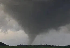
SOUTH-CENTRAL, Ind.–The National Weather Service (NWS) survey team from Indianapolis has confirmed that one tornado touched down in Brown County and moved through part of Western Bartholomew County during the severe weather on Friday, May 17.
On Sunday, the NWS team investigated damage in Brown and Bartholomew Counties. The tornado, rated an EF-2 with peak winds of 128 mph, started just before 7:30 p.m. and ended at around 8:10 p.m. Its path covered about 35 miles and was 350 yards wide. NWS also confirmed that this tornado first touched down in Monroe County during the severe weather on Friday.
The Bartholomew County Sheriff’s Office says most destruction is in the Grandview Lake area. Three to four houses had substantial damage, and roads were closed.
In the aftermath of Friday’s storms, around 500 people near the Grandview Lake area lost power. As of Sunday evening, Bartholomew County Rural Electric Membership Corporation (REMC) had restored power to most of the affected customers.
One injury was reported at the Brown/Bartholomew County line near Bellsville Pike just past Grandview Lake. Sheriff Chris Lane continues to ask people to stay away from the roads in the area while the damage is cleaned up.
The Brown County Emergency Management office reports significant damage to about 30 houses in that county. Four individuals were hospitalized with non-life-threatening injuries after Friday night’s storms. Preliminary reports indicated property damage ranged from mangled roofs to entire houses being destroyed. Emergency teams were to survey the full severity of the destruction on Sunday.
In Greene County (west of Bloomington), NWS said that one person died and three were injured in a tornado.